Agristack: Revolutionizing Agriculture with Budget 2024's Digital Initiative
- by B2B Desk 2024-07-24 12:41:45
In her Budget for the financial year 2024-25, Finance Minister Nirmala Sitharaman has put forth a proposal for Digital Public Infrastructure (DPI) tailored for the agriculture sector. The primary objective is to integrate over six crore farmers into a structured land registry system.
The Agristack digital initiative intends to revolutionize agriculture in a manner akin to how Aadhaar transformed digital payments and the Open Network for Digital Commerce (ONDC) impacted e-commerce.
This initiative involves digitizing various aspects of the farming sector, which holds significant implications for both farmers and the government. It aims to streamline operations, enhance transparency in land records, facilitate easier access to credit and subsidies, and ultimately improve productivity and livelihoods in rural areas.
What is Agristack?
Agristack serves as a central element of the Digital Public Infrastructure (DPI) designed for agriculture, alongside Krishi-DSS and Soil Profile Maps.
Imagine Agristack as a unified database housing comprehensive information about farmers. This includes their identity, land records, crop coverage, income, insurance details, loan history, crop specifics, and revenue records.
While certain data will be gathered directly from farmers, other information will be sourced from government databases through Application Programming Interfaces (APIs). This integrated approach aims to create a robust digital platform that enhances efficiency, transparency, and accessibility of agricultural data, benefiting both farmers and government authorities alike.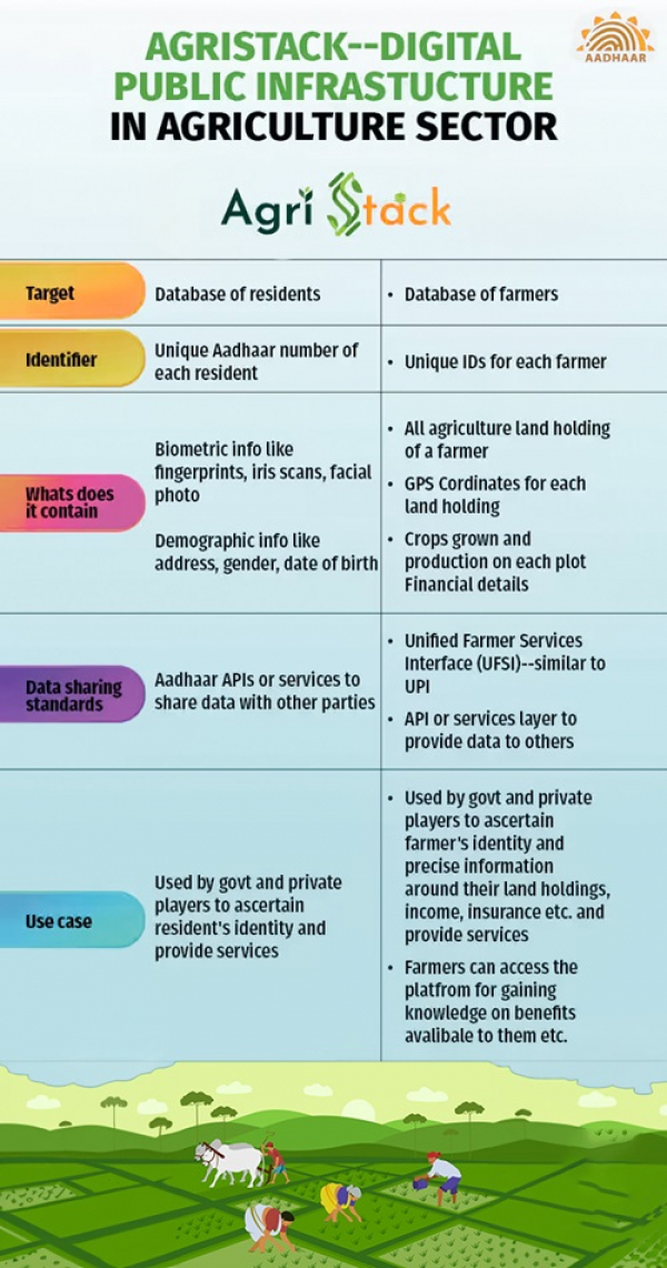
What about the data?
Agristack draws its data from three primary registries: the farmers' registry, geo-referenced village maps, and the crop sown registry.
Each farmer will receive a unique digital ID through the farmers' registry, which will be linked to their land records and Aadhaar details. Currently, states like Uttar Pradesh and Maharashtra are leading pilot initiatives to implement these IDs, aiming to enroll six crore farmers nationwide by the fiscal year's end.
The second source involves geo-referencing village maps and recording crop details through digital surveys conducted by states. These surveys utilize geo-referenced farmland maps and satellite imagery to gather precise data on crops planted.
Geo-referencing aligns satellite imagery with real-world geographic coordinates, primarily using GPS to accurately map cultivated areas. Technologies such as GIS-GPS, artificial intelligence, machine learning, and visual analytics play pivotal roles in delivering near real-time updates on crop status.
ISRO’s National Remote Sensing Centre (NRSC) provides satellite data, offering comprehensive insights into crop cultivation across India throughout various seasons. This integrated approach aims to revolutionize agricultural management, enabling informed decision-making and enhancing productivity nationwide.
Origins of Agristack: Building a Foundation for Digital Agriculture
In 2021, the Ministry of Agriculture and Farmer Welfare initiated the creation of Agristack by convening a task force. Their mandate was to draft a white paper, refine the concept, and establish the foundational framework.
The task force focused on developing the India Digital Ecosystem Architecture (IDEA), seeking feedback from experts, farmers, farmer producer organizations (FPOs), and the general public. This collaborative effort culminated in the concept of a Unified Farmers Service platform.
Following this, the ministry launched pilot projects in collaboration with various state governments to test and refine Agristack's functionalities on the ground.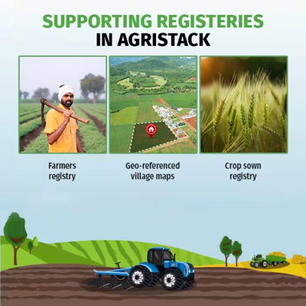
Why Agristack Matters? Revolutionizing Agricultural Data Management
The rationale behind Agristack lies in creating a unified digital platform to streamline information access and prevent redundancy for both government entities and farmers.
Currently, accessing benefits or developing initiatives for farmers requires separate requests for land records and IDs, often managed by different departments. Manual records can also be incomplete or inaccurate in many cases.
The Digital Public Infrastructure (DPI) aims to centralize comprehensive information accessible to all stakeholders. This integration allows agricultural supply-chain participants to optimize production and logistics planning. Farmers gain insights into optimal selling times and locations for maximizing profits, while also benefiting from innovative technologies.
For the government, Agristack facilitates improved planning, implementation, and targeting of agricultural schemes.
Moreover, Agristack enhances the ability to assess borrower creditworthiness and facilitates simpler loan and insurance processes, as highlighted in the 2019 report from the Steering Committee on fintech-related issues.
FAQs
Q. What is the mission of AgriStack for digital agriculture?
A. AgriStack is a government initiative to build an ecosystem that facilitates the delivery of digital agriculture services, including responsible advisories and access to quality inputs.
Q. What are the benefits of AgriStack?
A. Agri Stack helps the delivery and convergence of the Government schemes for the farmers, identification and authentication of the farmers, and enables delivery of financial services. Farmer Producer Organization (FPOs) are using digital apps to improve their business operations.
Q. Who launched the AgriStack?
A. The Digital Agriculture Mission 2021-2025 was launched in 2021 by the Ministry of Agriculture and five MoUs were signed with companies like Cisco, Jio Platforms, ITC Limited and National Commodity and Derivatives Exchange.
Q. What is the policy of AgriStack?
A. One such initiative introduced by the government to transform the agriculture sector in India is “AgriStack.” This initiative combines technology and digital databases to offer comprehensive support across the agricultural value chain, transforming how farming operates in India.
Q. What is a digital crop survey?
A. The Digital Crop Survey initiative will involve young individuals in rural areas, utilizing advanced technology like geo-fencing. This efficient method will simplify the process of capturing crop images in the field.
Also Read: Understanding Government Securities: An Overview of G-Secs
POPULAR POSTS
Andhra Pradesh Government Schools Partner with Canva for Free Digital Learning Access
by Aayush Ladha, 2026-06-30 11:50:02
How a Free AI Visibility Tool Helps Businesses Grow in the AI Driven Search Era
by Aakash Ladha , 2026-03-06 10:40:04
Loan EMIs to Drop as RBI Slashes Repo Rate - Full MPC December 2025 Highlights
by Shan, 2025-12-05 11:49:44
Zoho Mail vs Gmail (2025): Which Email Platform Is Best for Businesses, Startups, and Students?
by Shan, 2025-10-09 12:17:26
PM Modi Launches GST Bachat Utsav: Lower Taxes, More Savings for Every Indian Household
by Shan, 2025-09-24 12:20:59
$100K H-1B Visa Fee Explained: Trump’s New Rule, Clarifications & Impact on Indian Tech Workers
by Shan, 2025-09-22 10:11:03
India-US Trade Deal Soon? Chief US Negotiator Arrives in Delhi as Talks Set to Begin Tomorrow
by Shan, 2025-09-15 11:54:28

Follow on Insta
RECENTLY PUBLISHED
How Praveen Gowdru Went From Building VMEDO To Launching Tez Health And Why He Betting On Home Healthcare
- by Aakash Ladha , 2026-07-01 11:01:27
What Is LLM Visibility? A Simple Guide to Checking Your AI Visibility
- by Aakash Ladha , 2026-07-15 11:44:33
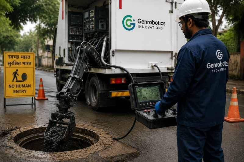
How a Kerala Startup is Using Robots to Clean Sewers and Manholes
- by Aakash Ladha , 2026-07-14 12:14:26

Luxemettle Redefining Indias Jewellery Market With Personalized Craftsmanship and Story Driven Design
- by Aakash Ladha , 2026-07-14 12:07:23

OpenAI Launches GPT-Live: Making Conversations with ChatGPT Feel Truly Human
- by Aayush Ladha, 2026-07-14 12:28:52
x
![logo]()